In the olden days, people only used manual techniques to get in the direction of new places but with the rapid growth of internet technology World Maps have been fixed on a single document making it easier for people to get the directions and locations of new places. The well-known Google incorporation has subsequently come up with Google Maps used by millions for directions and finding new locations.
This article will help you learn how to use Google Maps on your mobile phone to get directions and locations, in addition to clearing up many bad memories that ever happened to you such as:
1. If you have ever been excited to discover the name of the place you were accommodated.
2. You might once a time be unhappy about how some people responded to you when you request them to direct you somewhere you don't know.
3. Think back to a certain day you arrived in an unknown City at midnight and you couldn't find anyone to welcome you and or direct you to a dwelling site, at this time you alone had to find a way out.
Well! This piece of note is worthy for you to develop your knowledge in concern to using Google Maps for directions and locating new places, and assist you to resolve many of travels related issues, particularly If you travel more and more to unfamiliar places.
How To Use Google Maps on Smartphones for directions
The Google Maps application is available for both Android and iOS phones.
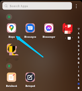
Head to the list of your mobile apps, find the Maps application, and open it. If it's not obtainable on your device you can download it for free in Google Play and the Apple app store respectively.
Before you start using Google Maps to get directions or locations your mobile phone must be connected to the internet, and have GPS turned on ( you can turn on GPS by swiping down or up in your phone shortcut menus depending on your phone type, the GPS is usually symbolized with a location icon). If you couldn't find it, just continue to the Map it will turn on automatically.
After all, launch your Maps and go after the following steps:
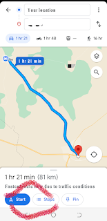
Step 1: Tap the directions icon.
Step 2: Choose your mode of transportation (car driving, Walking, Bike riding, or Train)
Step 3: Enter your destination in a search bar or tap it on Map and click the search button.
Step 4: Tap the start button to start navigation and follow up together with the Map directions.
The blue color lanes are your primary navigation road.
If there are alternative routes available toward your destination they will display in Grey colors, tap on them if you want to change your route.
Look at the top green navigation bar to see the navigation details, you will also be listening to the voice direction on your way for further convenience.
Tap Steps to see the directions separately in stages.
To stop navigation tap on the exit button.
What can you explore with Google Maps
With Google Maps you can explore and navigate to many different places such as:
- Nearby Hotels and Restaurants.
- Nearest Gas or Filing stations.
- Locate the nearest ATMs and POS.
- Locate Bus stops and stations.
- Find the Government office's location.
- Navigate to a given address.
- Track down your lost mobile phone.
- Locate the nearby shopping malls.
- Search for libraries, museums, attractions, Groceries, Hospitals, Pharmacies, Parks, Car washes, and more services near you.
- Share your Real-time location with family and friends.
How to know Your Location on Google Maps
Open the Google Maps app and tap on Location Icon.
You will see your precise location on the Map with complete details and relevant information.
You can zoom in on the Map with your two fingers to magnify its vision.
How to use offline Maps
Offline Maps is the reproduction of some parts of an online Maps. A user will select and download his desired location, and next time he will be able to use it offline.
Follow these steps to learn how to use offline Google Maps for directions:
Step 1: Open your Maps app >>> tap on your Google account profile picture in the top right-hand next to the mic icon.
Step 2: In the drop-down menus tap Offline Maps
Step 3: Tap "Select your Maps"
Use two fingers to zoom in and out and adjust to your desired area >>> then tap download.
After your download is successful you can use your Maps without an internet connection provided that the area is within the downloaded Map.
How to access Downloaded Maps
Any time you want to use your downloaded Maps offline open your app >>> tap your Google account profile picture >>> scroll down to offline Map ≥>> in the list of the downloaded Maps tap the one you want to use >>>> hit the Map with your finger to expand it >>> start enjoying your free offline Maps.
While using offline Maps you should know that some features are not available as in online versions such as alternative routines, and traffic information for driving directions. Transit, bicycling, and walking directions.
Read Also: How using Google Assistant on your Phones will Ease Your Work
What are the benefits of Google Maps
Google Maps has been a standard guide wrapped up with all existing places around the earth, it uses GPS to locate or navigate to any place. With Google Maps on your mobile device, you can rest assured that you never get lost in the corridor. Catch a glimpse here at something we discovered about Google Maps' benefits.
- Helps in Finding and figuring out new places.
- Locating new directions.
- Helps in Finding your existing location.
- You can use Google Maps to share your real-time location with family and friends.
- Add your business location to Google Maps which helps people find your business in Google Maps and search engines.
- Learning the distance and number of kilometers between two locations.
- Understanding the precise speed limits while driving.
- It feeds you with an estimated time to reach a certain place.


![3 Best Browsers For Android Phones [Tested and Confirmed]](https://blogger.googleusercontent.com/img/b/R29vZ2xl/AVvXsEjCRf5Zv4oH-ozjIzE5KQn_UtZlbL67XXDF8cFY9f06iYtR_QrUb3vDCPuPtt35uyI-gj5ueASBKVsDyhpjnVt5GV_G4mJXypsJj-Bm2apH8210nbrrQUUgnxOurE55dVHfssJCQpAWmmg0tEUQopArCu4DzmiS8kynkI_Y7EJv7Z3-40KH1xsT5ReXgJo/w72-h72-p-k-no-nu/1688908227364logo.png.png)
0 Comments